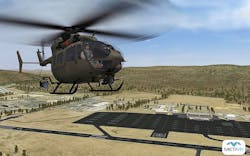
MetaVR visuals selected for U.S. Army National Guard UH-72A Lakota synthetic flight training systems
BROOKLINE, Mass., 13 Aug. 2015. MetaVR delivered 48 Virtual Reality Scene Generator (VRSG) licenses to Fidelity Flight Simulation Inc. (F2Si) for the production of eight UH-72A LakotaSynthetic Flight Training Systems (SFTS) for the Army National Guard (ARNG).
Last fall, the U.S. Army Program Executive Office for Simulation, Training, and Instrumentation (PEO STRI) awarded F2Si the contract to build the eight UH-72A Lakota SFTS Trainers and deliver them to the Eastern and Western regional Army Aviation Training Sites (EAATS and WAATS), starting in May 2016.
Each mobile UH-72A SFTS is comprised of a 53-foot, self-contained tractor trailer, which houses the UH-72A flight training device (FTD).
The two-seat cockpit FTD will use six VRSG licenses: four for out-the-window views and two for sensor views. The training simulator will feature a collapsible partial fabric dome display (220 degrees x 60 degrees) provided by Immersive Display Solutions in Kennesaw, Ga.
The UH-72A FTD, which will exceed FAA Level 6 Flight Training Device equivalent, will support institutional, organizational, and sustainment training for Active Component and Reserve Component aviation units. The training system will provide the capability for aviation units to train and sustain the performance of selected critical tasks and will also allow UH-72A qualified aviators to maintain proficiency in high-risk tasks.
As part of the VRSG sale, MetaVR is building 3D virtual terrain of 16 U.S. military and commercial airfields for training purposes. The virtual airfields are compiled with imagery ranging from 15-30 cm per-pixel resolution, coupled with 3 meter-per pixel National Elevation Dataset (NED) or DTED 1 elevation data. Each virtual airfield will have one or more runway models, a geospecific control tower model, runway lights and signage, and geolocated geotypical models ranging from hangars, offices, storage facilities, and other structures in the area of interest.
The runway models use a custom digital elevation model (DEM) to provide greater than 95 percent accuracy for runway elevations to match FAA charts. The virtual airfields are built with MetaVR Terrain Tools for Esri ArcGIS, followed by the use of VRSG Scenario Editor for the placement of persistent cultural features on the terrain.
MetaVR, founded in 1997, develops commercial PC-based software for the military simulation and training markets, featuring high-speed 3D visualization content and rapid creation of networked virtual worlds using real-world data. MetaVR's real-time visual systems provide the fidelity of geospecific simulation with game-quality graphics. Users can build (with real-world photographic imagery, elevation data, and feature
data) high-fidelity virtual worlds with our terrain generation tools, and render in real time, at 60Hz frame rates, the resulting virtual world with the real-time 3D visualization application, Virtual Reality Scene Generator. MetaVR systems are used for applications such as UAS trainers, manned flight simulators, mission planning and rehearsal, JTAC simulation training, urban operations training, and emergency response management training.
