BAE Systems to build undersea navigation without GPS for unmanned underwater vehicles (UUVs)
Officials of the U.S. Defense Advanced Research Projects Agency (DARPA) in Arlington, Va., have chosen the BAE Systems sensor processing and exploitation group in Merrimack, N.H., for the Positioning System for Deep Ocean Navigation (POSYDON), program, BAE officials say.
The DARPA POSYDON program aims to develop an undersea navigation system to enhance the U.S. Navy’s ability to provide precise, global positioning throughout the ocean basins while remaining below the ocean’s surface, BAE officials say. The value of the contract was not released.
POSYDON seeks to develop undersea navigation capability that enables submerged UUVs and submarines to navigate over long periods and long ranges without surfacing for a GPS fix to fine-tune their positioning.
Today's UUVs typically must surface for a GPS fix periodically to update their inertial navigation systems. Any time a submerged vessel surfaces it risks detection. POSYDON also can help assure accurate navigation when GPS signals are not available or jammed by the enemy.
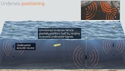
A BAE Systems team will create a positioning, navigation, and timing system designed to enable vehicles to remain under water by using multiple, integrated, long-range acoustic sources at fixed locations around the oceans.
BAE systems engineers also will develop the vehicle instrumentation necessary to capture and process acoustic signals for accurate navigation, company officials say. Other members of the BAE Systems POSYDON team are the University of Washington, the Massachusetts Institute of Technology, and the University of Texas at Austin.
POSYDON seeks to develop an undersea system that provides omnipresent, robust positioning, navigation, and timing independently of GPS and inertial navigation, DARPA officials say.
The central problem revolves around the inability of GPS satellite signals to penetrate through water. Inertial measurement units, while effective, lose their accuracy over time.
Related: Special Operations Command looking for next-gen underwater navigation instruments
Instead, a small number of acoustic beacons at known fixed positions around an ocean basin can help manned and unmanned submersibles calculate the absolute range to several source signals to obtain continuous, accurate positioning without surfacing.
POSYDON seeks to eliminate the need for expensive IMU and velocity sensors. Host vehicles of interest to the POSYDON program include UUVs of all types, although DARPA also encourages solutions that other undersea vehicles and systems could use.
DARPA researchers are interested in positioning, navigation, and timing technologies that are available for the deep ocean, over continental shelves, and in shallow coastal waters and harbors, while being immune-by-design to attempts to jam or disrupt its navigational capabilities.
POSYDON will involve acoustic measurement modeling, acoustic source and waveforms, at-sea data collection and demonstration, and optional adjunct technologies.
Related: Precise underwater navigation with sonar is aim of Navy research contract to Penn State
Acoustic measurement modeling involves underwater acoustic signal propagation channels that can overcome challenges in time-varying multipath propagation and multipath delay; Doppler spread due to vessel motion relative to the acoustic source(s) and ocean environment; bandwidth-limited signals; and convergence zones.
Acoustic source and waveforms involves finding an acoustic source and determine the number, location, and depth of the sources for basin-scale coverage. At-sea data collection and demonstration, meanwhile, involves at-sea data collection to validate acoustic measurement modeling and acoustic source and waveforms.
Adjunct technologies could involve stand-alone positioning, navigation, and timing solutions that involve other kinds of component, processing, or modeling approaches.
For more information contact BAE Systems Electronic Systems online at www.baesystems.com, or DARPA at www.darpa.mil.
