By Ben Ames
WASHINGTON - Leaders at the National Oceanic and Atmospheric Administration (NOAA) in Washington awarded three contracts of $10 million each to build a series of next-generation weather satellites for the Geostationary Operational Environmental Satellite Program (GOES-R).
The six-month contracts are Program Definition and Risk Reduction (PDRR) studies containing two options, which could add 16 months and result in a total value of $30 million. Each team will analyze the GOES-R requirements and develop a solution using advanced sensing technology, ground data processing, communications, and command and control.
The PDRR phase will end with a “fly-off” competition in 2007, with NOAA selecting one team to build the GOES-R end-to-end system. Agency officials say they plan to launch the first satellite in 2012.
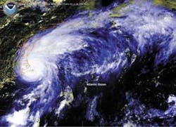
NOAA’s GOES satellites take pictures of hurricanes as they develop.
The first contract went to a Boeing Co. team based in St. Louis, including Harris Corp. in Melbourne, Fla.; Ball Aerospace & Technologies Corp. in Boulder, Colo.; Atmospheric and Environmental Research Inc. in Lexington, Mass.; and Carr Astronautics in Washington.
The second contract went to Lockheed Martin Space Systems Company (LMSSC) in Denver, with teammates Lockheed Martin Integrated Systems & Solutions (IS&S) in Gaithersburg, Md., to provide the systems integration and ground segment; and 15 additional industry and academic partners.
The third contract went to Northrop Grumman Corp. in Redondo Beach, Calif. with teammate Raytheon Co. in Waltham, Mass.
Each team will design a platform with enabling technologies including enhanced data handling on the ground, as well as an improved spacecraft integrated with state-of-the-art sensors, such as the advanced baseline imager and the hyperspectral environmental suite.
These next-generation GOES-R satellites will collect 100 times more data and scan the Earth three-to-five times faster than previous systems.
The new satellites also will carry instruments that offer dramatic improvements in the ability to observe the Earth and the sun and will lead to more accurate predictions of the intensity and landfall of hurricanes with longer lead times than today, significantly improving weather forecasts, experts say.
In addition, GOES-R will field new capabilities, such as a coastal waters imager capability that will view the entire U.S. coastline every three hours at high resolution. This instrument will evaluate the ocean’s biological productivity, detect harmful algae blooms, and assess coastal zones after severe storms for protection of fragile ecosystems.
These new and augmented capabilities provided by GOES-R will lead to significant economic benefits to the nation in the areas of weather and water, climate, ecosystems monitoring and management, and commerce and transportation.
GOES satellites circle the Earth in a geosynchronous orbit, which means they orbit the equatorial plane of the Earth at a speed matching the Earth’s rotation. This allows them to hover continuously over one position on the surface. The geosynchronous plane is about 22,300 miles above the Earth, high enough to allow the satellites a full-disc view of the Earth.
Because the geosynchronous orbit places the satellite above a fixed spot on the planet’s surface, the spacecraft can provide a constant vigil for the atmospheric “triggers” for severe weather conditions such as tornadoes, flash floods, hail storms, and hurricanes.
Scientists will be able to use new observations to monitor the variability of atmospheric constituents associated with air quality and climate change. The aviation weather community will also benefit from more accurate upper level wind measurements, better predictions of clear air turbulence events, and an improved ability to detect and track volcanic ash that can damage jet engines.
Also in the GOES program, DRS Technologies Sensors & Targeting Systems unit in Cypress, Calif., won a $38 million contract in November to develop advanced, infrared sensors for next-generation imaging systems.
DRS received initial funding of $8.2 million from the ITT Industries Inc. Space Systems Division in Fort Wayne, Ind. Delivery of the sensors is expected to commence in 2007 and continue through 2009 following the delivery of the fourth flight unit.
For these awards, DRS will design and develop infrared sensors for five flight units supporting next-generation geostationary weather satellites and will provide focal plane array (FPA) sensor modules for the GOES Advanced Baseline Imager.
DRS-produced infrared sensors and FPAs will be integrated into the Advanced Baseline Imager (ABI). DRS’s FPAs provide spectral sensitivity for high-resolution images, while recording the position, intensity and wavelength of radiation emitted by spatial objects.
For more information, see goespoes.gsfc.nasa.gov/goes/spacecraft/r_spacecraft.html or noaasis.noaa.gov/NOAASIS/ml/genlsatl.html.

