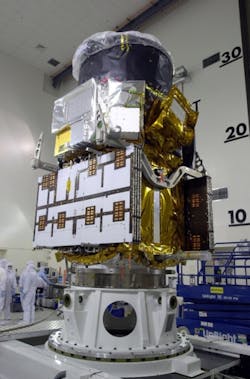
Earth-observing spacecraft CALIPSO marks fifth year in space, takes three-billionth lidar profile
CALIPSO works by sending out 20 laser pulses every second, and each is only 20 billionths of a second long. “If you add all the pulses up, the laser has only produced light for one minute," explains Chip Trepte, CALIPSO's project scientist, based at NASA's Langley Research Center in Hampton, Va.
The satellite provides data to scientists and researchers in more than 35 countries, helping answer questions about Earth's warming and cooling patterns as they are affected by clouds and aerosols, tiny particles suspended in the air. "CALIPSO is continuing to provide very valuable information about climate, the weather, and air quality. We now know where the layers of pollution are and how they move over the globe. We didn't know that five years ago," Trepte says.
The satellite uses lidar, which measures the thickness and composition of clouds and aerosol layers and their altitudes.
CALIPSO is part of a constellation of five satellites and a collaboration between NASA and the Centre National d'Etudes Spatiales (CNES), the space agency of France. Langley is leading the CALIPSO mission and providing overall project management, systems engineering, and payload mission operations.
CNES provides the Proteus spacecraft, a radiometer instrument, and spacecraft mission operations; whereas Hampton University in Hampton, Va., provides scientific contributions and Ball Aerospace developed the lidar and on-board visible camera.
