Air Force researchers look to Earth's magnetic fields for reliable navigation in GPS-denied environments
WRIGHT-PATTERSON AFB, Ohio – Military leaders have been warning of the fragility of the satellite-based Global Positioning System (GPS) for years and researchers have been working on ranging from quantum clocks to inertial navigation. Defense One reports. Continue reading original article
The Military & Aerospace Electronics take:
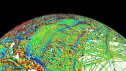
20 Aug. 2020 -- The U.S. Air Force is adding a new one, using the Earth’s magnetic fields as a secure way to detect location for aircraft and possibly other vehicles. Magnetic fields emanating from the earth’s surface vary in intensity, just like topography, and so-called magnetic anomaly maps of those fields have existed for years.
Back in 2017, Aaron Canciani, an assistant professor of electrical engineering at the Air Force Institute of Technology at Wright-Patterson Air Force Base, Ohio, set out to see if magnetic sensors (magnetometers) affixed to aircraft could measure the intensity of those magnetic fields and, thus, locate the plane based on where it was in relation to those landmarks.
His paper shows how to outfit a Cessna light general-aviation aircraft with magnetometers in the rear and the front. Forty flight-hours worth of navigation data and a lot of work reducing noise from the readings proved the idea viable.
John Keller, chief editor
Military & Aerospace Electronics

