Radar, short for radio detection and ranging, has long been a crucial technology in military operations. Using radio waves that bounce off objects, radar systems proved adept at recognizing and tracking objects from transmitter antennas and widely came into military use during World War II.
A primary military use for radar is in surveillance and reconnaissance. Radar systems monitor airspace, land, and sea areas to detect and track enemy movements -- including aircraft, ships, and ground vehicles. This constant monitoring aids in maintaining situational awareness and gathering vital intelligence.
In air defense, radar detects incoming aircraft, missiles, and other aerial threats. It provides early warning and targeting information for anti-aircraft and missile defense systems. Additionally, radar plays a critical role in target acquisition and fire control. It locates and tracks targets, guides missiles, and ensures accuracy in artillery fire for air-to-air and surface-to-air engagements.
Radar also aids in the navigation and guidance of military aircraft, ships, and ground vehicles, especially under poor visibility conditions. This capability extends to the guidance of precision-guided munitions, ensuring they reach their intended targets accurately. Furthermore, military radar systems often include weather monitoring capabilities, which are vital for planning operations and ensuring the safety of personnel and equipment.
In electronic warfare, radar detects and jams enemy radar systems and communications, disrupting enemy operations and protecting friendly forces from detection. Naval radar systems are particularly important for surface search, navigation, and targeting. They detect and track surface ships and submarines, assisting in maritime surveillance and combat operations.
Counter-battery radar systems are designed to detect and track the trajectory of incoming artillery shells, mortars, and rockets. This allows for counter-battery fire to neutralize enemy artillery positions effectively. Additionally, radar is employed in search and rescue missions to locate downed aircraft, ships in distress, and missing personnel.
Speed of light
Less than two decades after militaries found ground-breaking uses for radar, the U.S. Department of Defense (DOD) and the National Aeronautics and Space Administration (NASA) harnessed lasers to use light in place of radio waves to determine distance with lidar [LIght Detection and Ranging].
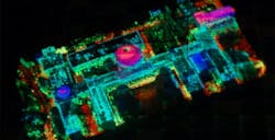
In terrain mapping and reconnaissance, lidar creates high-resolution 3D maps of terrains, aiding in mission planning, navigation, and operational strategies. These maps offer insights into topography, obstacle identification, and route planning for troops and vehicles.
Mounted on drones, piloted aircraft, or ground vehicles, lidar systems assist in target identification and tracking. By delivering accurate distance measurements and detailed imagery, lidar aids in recognizing and distinguishing between various objects, including enemy equipment and personnel.
lidar technology is instrumental in obstacle detection and avoidance for autonomous vehicles such as drones and ground robots. Real-time obstacle detection enables these vehicles to navigate complex environments safely by adjusting their paths in response to detected obstacles.
lidar also proves invaluable for identifying potential hazards like improvised explosive devices (IEDs). By scanning the ground surface and analyzing reflected light, lidar can identify anomalies indicative of hidden threats, enabling safer operations in hazardous environments.
Military engineers use lidar to assess the structural integrity of critical infrastructure like bridges and buildings. By generating detailed 3D models, lidar aids in evaluating damage, planning repairs, and ensuring the safety and functionality of infrastructure.
Integrated into surveillance systems, lidar contributes to gathering intelligence over large areas. Its ability to operate in various weather conditions and provide precise measurements enhances the effectiveness of surveillance operations.
Lidar-generated data is utilized in combat simulation and training programs, leveraging virtual reality (VR) and augmented reality (AR) technologies to create realistic combat scenarios. This immersive training improves soldiers' preparedness and tactical skills by allowing them to train in environments closely resembling real-world conditions.
In range
Radar and lidar help military and civilian personnel keep an eye on what's above, below, and in front of them, but using each comes with benefits and drawbacks.
Radar offers significant benefits because it works well in adverse weather conditions. Unlike lidar, radar remains effective in rain, fog, and snow to render reliable data even in low visibility. Additionally, radar waves can penetrate obstacles like foliage, dust, and even walls to detect objects through barriers.
However, radar has some drawbacks -- primarily its lower spatial resolution compared to lidar. This limitation means radar is less capable of generating detailed 3D maps and distinguishing between closely spaced objects. Additionally, radar is generally less effective at classifying objects, providing good information about the presence and distance of objects but less detailed data about their shape and size. Radar also can be susceptible to electromagnetic interference from other devices operating on similar frequencies, which can affect its accuracy and reliability.
Lidar excels in providing high-resolution 3D mapping to offer detailed spatial information about the environment. This high resolution makes lidar highly effective for applications requiring precise object detection and mapping. lidar also excels at accurate object classification, distinguishing between different types of objects based on their shape and size. lidar offers precise distance measurements with high accuracy, which is crucial for applications needing detailed and accurate spatial data.
Despite its strengths, lidar has its own set of disadvantages. Its performance can be significantly degraded by adverse weather conditions such as heavy rain, fog, and snow, which scatter the laser light and reduce accuracy and range. lidar generally has a shorter effective range compared to radar.
Getting higher
Lidar generally has a much shorter range than radar, yet by taking a top-down approach from high altitudes or even from space, lidar can make precise electro-optical quickly.
Last decade, the U.S. Defense Advanced Research Projects Agency (DARPA) developed the High-Altitude lidar Operations Experiment (HALOE), which collected data more than ten times faster than radar. HALOE was able to map 50 percent of Afghanistan in 90 days.
The HALOE project used arrays of Geiger-mode avalanche photodiode (GmAPD) detectors, which are capable of detecting one photon. This extreme sensitivity enables lidar sensors to operate at unprecedented altitudes and achieve area collection rates exceeding 1,000 square kilometers per hour, equivalent to about 620 square miles.
Beyond military applications, the technology developed for HALOE is expected to benefit civil mapping, monitoring of critical infrastructure, and disaster relief efforts.
Using lidar at altitude also is helping the U.S. National Weather Service (NWS) to research how to improve upper-air weather observation.
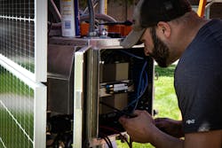
This spring, Honeywell in Phoenix and U.S. National Oceanic and Atmospheric Administration (NOAA) joined to explore the utility and value of data from Honeywell’s High Altitude lidar Atmospheric Sensing (HALAS) system. HALAS is a remotely operated, ground-based weather information system that uses laser pulses to provide near real-time, high-altitude atmospheric data with greater accuracy and spatial relevance than traditional weather balloons. This system will allow NOAA to collect atmospheric measurements at much faster intervals, leading to a better understanding of rapidly changing weather patterns and potentially improving the accuracy of weather forecasts.
“Understanding the atmosphere above the surface is vital to predicting the evolution of weather phenomena, from local afternoon thunderstorms to expansive blizzards and hurricanes,” says Jordan Gerth, a meteorologist at the National Weather Service Office of Observations. “Through our partnership with Honeywell, this research project could help us identify a new way to gather the weather observations we need.”
HALAS provides forecasters with weather data on wind speed and direction, humidity, temperature, and density from altitudes exceeding 100,000 feet above the Earth’s surface. This new, location-specific atmospheric column of data available to NOAA meteorologists could enhance their ability to understand weather patterns and improve existing weather prediction models.
Even higher
Like DARPA’s HALOE, space-based lidar is also for topographical mapping. This technology enables the creation of high-resolution maps of planetary surfaces, including Earth, the Moon, Mars, and other celestial bodies. For example, the National Aeronautics and Space Administration’s (NASA's) Mars Global Surveyor used lidar to map the topography of Mars. Additionally, space lidar is used in vegetation and forest analysis by measuring forest and vegetation structures to assess biomass, carbon stocks, and land cover changes. The Global Ecosystem Dynamics Investigation (GEDI) mission on the International Space Station (ISS) uses lidar to create 3D maps of Earth's forests.
Space lidar also plays a part in atmospheric studies by measuring parameters such as aerosols, clouds, and gas concentrations. NASA’s Cloud-Aerosol lidar and Infrared Pathfinder Satellite Observations (CALIPSO) mission used lidar to study cloud and aerosol layers in the Earth's atmosphere.
Radar has also been embraced in space by civilian-commercial interests as well as government and military. One of the most common applications of space radar is synthetic aperture radar (SAR), which creates high-resolution images of the Earth's surface by synthesizing a large aperture as the radar antenna moves along the orbital path. SAR is for topographical mapping, vegetation analysis, and monitoring natural disasters. Interferometric Synthetic Aperture Radar (InSAR) enhances insights using multiple SAR images taken at different times to measure ground deformation and topography, detecting subtle changes in the Earth's surface caused by earthquakes, volcanic activity, and subsidence.
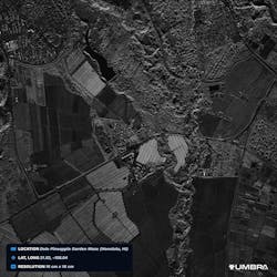
Last year, Umbra, a Santa Barbara, Calif.-based company specializing in advanced space radar technology, created a SAR image with a resolution of 16 centimeters, purportedly the highest-resolution commercial satellite image ever released. Additionally, the company started furnishing the highest-quality data its satellites can capture, encompassing all formats and resolutions, including complex data surpassing 25 centimeters, marking a significant advancement.
Umbra's capacity to enhance its data offerings for commercial clients stems from NOAA's removal of the temporary licensing conditions that previously governed Umbra's operations. Following the update in NOAA licensing, Umbra integrated 25-centimeter imagery, incorporating the newly unlocked phase history data into the Open Data Program.
Space radar systems also are altimetry to measure the height of the Earth's surface, including ocean topography, ice sheets, and land elevations. By emitting radar pulses straight down to the surface and measuring the return time, radar altimeters provide precise altitude data used for sea level monitoring and climate research. In planetary exploration, radar systems map the surfaces and subsurfaces of other planets and moons.
Because SAR allows for observing time-critical applications and changes, in 2022 DARPA announced its Fiddler program to improve automatic object recognition in SAR images. Object recognition often requires significant examples to train machine learning classification algorithms. Obtaining training data can be time-consuming, expensive, and even impossible in dynamic conditions.
The use of machine learning and computer vision to generate training data in dynamic ocean environments is of particular interest to this program.
Additionally, space radar systems monitor and track space debris and other objects in Earth's orbit to mitigate the risks of collisions with satellites and space stations. Space radar can penetrate clouds, rain, and dust, providing reliable data regardless of weather conditions. Their ability to detect objects over long distances makes them suitable for large-scale and remote sensing applications.
However, the technology faces challenges such as significant power consumption, atmospheric interference affecting accuracy, and the complexity and cost of development and deployment. Despite these challenges, space lidar systems remain invaluable for a wide range of scientific and observational missions.
Fieldwork
Lidar and radar sensors, alongside vision systems, have proven incredibly useful in allowing for air, sea, and ground vehicles to operate in varying degrees of autonomy.
dSPACE in Wixom, Mich. provides development and testing solutions for electronic control units (ECUs) and mechatronic systems. Their primary focus is on the automotive industry, although their technology is also utilized in other sectors such as aerospace, robotics, and industrial automation.
Vivek Moudgal, sales and marketing vice president for dSPACE, explains that the company provides software development and testing tools including hardware-in-the-loop (HIL) simulators. These simulation tools help automotive engineers evaluate the performance, handling, and safety of vehicles under various driving conditions and scenarios in the lab much before the vehicles are on the road.
With autonomous systems proliferating in military and civilian environments, lidar, radar, and vision systems are crucial not only for successful missions but safely operating in dynamic environments like driving at highway speeds.
Moudgal notes that in automated vehicles, the environment sensors work with internal vehicle signals to provide a holistic view around the vehicle.
"You need to have a 360-degree view of what's happening around you, both in the near distance - basically close to the vehicle - as well as further distance, especially if you're driving at highway speeds," Moudgal says. "When you look at every individual sensor, cameras give you really vivid information, but can be prone to failures either if driving into the sun when you have overexposure, in dust storm, or snow, etc. or if there is dirt on the lens."
The dSPACE executive notes that radar, on the other hand, is much less affected by dirt, dust, and glare and enables systems to better accurately gauge the vehicle's distance from any object around it.
"Cameras are good at the perception of perceiving objects, classifying objects, doing things like that, [but] where cameras tend to be weak is distance measurements - that's what radar's really good at," Moudgal says.
Like cameras, Moudgal explains that lidar can also be negatively impacted by environmental factors like rain or snow, saying "they will be blinded in many cases." The executive also says that lidar is capable of producing higher resolution images than radar, but there are significant size and cost concerns for vehicles built to a price.
John Gagnon, who heads dSPACE's business development and field application initiatives for radar test systems, says that radar - specifically advancements brought about by 4-D radar - can provide improved and more accurate awareness around vehicles compared to previous technologies.
"Four-D radar can come in ten [times] less the cost of lidar and you're getting good enough point data where these new 4-D imaging radars are getting good at elevation measurements, which is typically where previous generation of radars always had a problem with."
Conventional radar systems function in three dimensions, furnishing spatial data about object locations relative to the radar transmitter/receiver. However, 4D radar systems augment this spatial information with the temporal dimension, enabling the tracking of objects as they traverse through space. This capability enhances the accuracy of forecasting trajectories and behaviors of moving targets, proving particularly advantageous for applications like air traffic control, maritime surveillance, weather monitoring, and military operations.
4D radar systems achieve this functionality by continually emitting radar pulses and examining the Doppler shift in the frequency of the returning signals. Through monitoring frequency alterations over time, these systems ascertain the velocity of moving objects concerning the radar, along with their direction of movement. This data is subsequently amalgamated with spatial information to construct a comprehensive depiction of the target's motion in three-dimensional space across time.
"So, if you can get that data for a cheaper per unit cost and you're also filtering out a lot of the noise by having less points, that can become a good thing," Gagnon says.
His colleague Moudgal agrees and says, "I think that's an important aspect...if you look at it a camera, you can increase the resolution, you can increase the frame size and you can increase the frames per second. But all that comes at a cost of how much the back-end connection has to be to the computer to transfer the data, and at the same time, once the data is in the computer, how quickly can it be computed?"
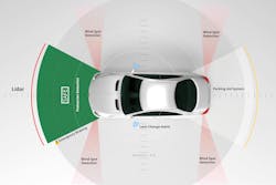
While military vehicles also must contend with concerns with size, weight, power, and cost (SWaP-C) like their civilian counterparts, the ability to carry more sensors and embedded systems to process data allows even greater redundancy and situational awareness. Lidar and radar are frequently integrated to capitalize on the strengths of both technologies. LiDAR offers high-resolution 3D mapping and precise obstacle detection, while radar provides reliable detection and tracking capabilities in all weather conditions. Together, they enhance a vehicle's ability to operate autonomously, navigate complex terrains, and accurately detect threats.
Combining data from both lidar and radar systems results in improved situational awareness and decision-making. For instance, lidar can deliver detailed information about the shape and size of an obstacle, whereas radar can determine its speed and movement. This integrated approach ensures a comprehensive understanding of the environment and significantly boosts the vehicle's overall operational effectiveness.

Jamie Whitney
Jamie Whitney joined the staff of Military & Aerospace Electronics and Intelligent Aerospace. He brings seven years of print newspaper experience to the aerospace and defense electronics industry.
Whitney oversees editorial content for the Intelligent Aerospace Website, as well as produce news and features for Military & Aerospace Electronics, attend industry events, produce Webcasts, oversee print production of Military & Aerospace Electronics, and expand the Intelligent Aerospace and Military & Aerospace Electronics franchises with new and innovative content.


